Piz Palü Ostpfeiler (East ridge; 3882 m) and traverse, Bernina


1 comments
route: Diavolezza cablecar top station (2973 m) - Piz Palü east ridge (S-) - Piz Palü main summit (3901 m) - Piz Spinas - Fortezza - Diavolezza cablecar top station


Thursday afternoon we took the cablecar to Diavolezza station. From there, we followed the path towards Pers Glacier and decided for a campsite very close to the Furcla d'Arias. Access to water was close and on the ridge there were a few flattened and sheltered sites suggesting that the spot can be busy sometimes. Today it was quite. We are lucky!


The views from the campsite in the evening light were spectacular!! We enjoyed our dinner, and we could not take our eyes from the three prominent ridges of Piz Palue.

From left to right: Piz Cambrena, Piz Palue (with eastern ridge, Bumiller ridge and western ridge), Bellavista.

The next morning, we left the campsite at 4 am. We approached the base of the eastern ridge via the Pers glacier, meandering between the huge crevasses, in the moonlight. The moon was so bright, we could easily see the crevasses and the best ways to avoid them. It took us about an hour and a half to get to the base and there was something very special and magical about the tranquility and the moon escorting us.
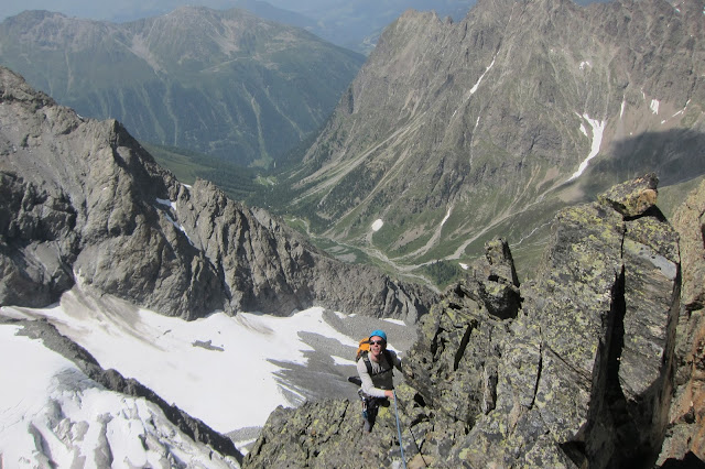
The start of the climb is marked with two bolts and a few meters above you'll find a belay. We climbed the first few meters in the dark, and as we approached the ridge, it dawned and we could make out the crevassed glacier beneath us and in the morning sun Piz Bernina and Bianco ridge looked welcoming.
 Looking down to the Pers glacier. 

From left to right: Piz Bernina, Bianco ridge and Piz Morteratsch.

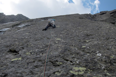
The climb was fun! More or less constant difficulties in grades II - III with some moves that were a little harder (IV), mostly on plates, a very few steep sections, but good solid holds throughout! The crux is a gendarme that can be climbed directly or climbed around to the left (east).  We decided for the direct, bolted variante.  

Roland preparing a belay just below the gendarme.
  Looking back once more. Behind me the gendarme.
Once the tower is passed, the climbing becomes easier again, and soon we reached the snow-ridge. The snow was very firm and good to walk on.
The 45° angled slope and the ridge below.  

  On the eastern summit!
We reached the eastern summit around 10 am. Because the weather looked good for another few hours we decided to traverse the main summit and Piz Spinas and descend via Fortezza to the Pers glacier and back to our campsite. Last year, we traversed Piz Palü in the opposite direction (see http://stefanie-upandunder.blogspot.co.nz/2012/08/piz-palue-3901-m-west-east-traverse.html) and this traverse is absolute stunning!
The Fortezza offers a quite comfortable descent as the way through the rocks is well marked with yellow signs, and there are a few abseil rings if you don't feel quite as comfortable climbing down exposed steep sections (just as me ..).
Crossing the Pers glacier was okay, although the crevasses forced us to meander quite a bit. We were very close to our campsite, maybe 20 min away, when thunder rolled it and a few lightenings scared me. As we reached our campsite it started to hail, and we took down our tent, quickly packed our belongings, and ran off to Diavolezza station. 
We made it safe to catch the cablecar at 4 pm, happy to be back from the mountain just in time, and filled with yet another thrilling mountain experience! 

Piz Roseg (3937 m) via Eselsgrat, Bernina


0 comments
route: Pontresina - Tchierva Hut - Eselsgrat (ZS-) - Piz Roseg (3937 m)


We started at 3:15 am at the Tchierva Hut. It was not difficult to find the route even though it was dark, because the approach was well marked with cairns and a few reflectors. Once we reached the upper glacier, we crossed west  to the start of the "Eselsgrat". It was daylight by then, and two more parties approached to climb the ridge.
The conditions for the climb were ideal: the rock was dry, with difficulties up to III, bolts and belays when necessary. 

Roland just before the first crux. Ahead of him a second party.

We left the ridge, and approached the "Schneekuppe", climbing the glacier. 

Roland on the glacier, the "snowy summit (Schneekuppe)" to his left at the background. The real summit is hiding behind.

I was exhausted and did not feel to climb the summit, so Roland went along to climb it himself.
 Roland on the summit of Piz Roseg.

Meanwhile I was enjoying the impressive views over to Piz Scercen (left) and Piz Zupo (background) with part of the Bellavista terrace and Piz Palü. A party climbed Piz Scercen today .... when will we be standing on this summit?


Solstein Traverse East-West


0 comments
starting point: Seegrube, Innsbruck, 1906 m
route: Frau Hitt - Brandjochboden - Brandjochkreuz - Vordere and Hintere Brandjochspitze - Hohe Warte - Kleiner  Solstein (2637 m) - Grosser Solstein - Hochzirl
climb: III-


The Karwendel is the part of the Northern Limestone Alps, which lies between the Inn and the Isar, so it is located on and around the Austrian-German border. For me, the Karwendel epitomizes the fascination of mountain scenery: the luscious green of alpine pastures, crowned by rugged mountain peaks and ruptured by vast corries.

Living in Innsbruck, you see the southern range of the Karwendel nearly every day. The prominent peaks look at you when you're running your errands in town, smile at you when you're having a drink at the Marktplatz; they are majestic, impressive - and inviting.
This time we wanted to be in this position and smile down to town. We decided to traverse the Karwendel-range, from Seegrube in the East to Grosser Solstein in the West.

Overview of the traverse as seen from Brandjochkreuz.

We decided for a lazy approach and took the Nordkettenbahn, a mountain lift that took us to Seegrube, the starting point of our adventure. From there we hiked to Frau Hitt Sattle, and climbed up Frau Hitt.  The legend is that Frau Hitt was an avaricious and narcissistic giant woman who petrified when she gave the order to wash her son with white bread dipped in milk while everyone else was starving. Today you can climb up the petrified woman, it's graded III- from the west and III from the east and takes about 15 - 30 min from the Frau Hitt saddle.
From Frau Hitt we descended to Branjochboden, hiked up Brandjochkreuz and took the southern ridge (Suedgrat) to the Vordere Brandjochspitze. The ridge was well marked and rather beautiful and diversified to climb! There are two spots, III-, one of them is a terrifying big step you have to do over the abyss! This time it was me who was half petrified, not knowing how to do this giant leap!


First part of Brandjochspitze Southern Ridge 

On the ridge with views to Innsbruck and the Inn valley.
 
I managed and was rewarded with nice climbs along corners and short slabs before reaching the summit of Vordere Brandjochspitze. Including the Frau Hitt de-tour, it took us about three hours from Seegrube. From here on, it was an alpine climb with no marks or cairns to follow. The climb up to Hintere Brandjochspitze was not too difficult but there was a lot of loose rocks! From here, we stuck to the ridge for the majority of the climb. The traverse from there to Hohe Warte was exposed and rather brittle with a lot of loose rocks. The traverse from Hohe Warte to Kleiner Solstein was not as brittle with some good short climbing sections on solid rock. The descend to  Grosser Solstein was without technical sections. It took us five hours from Brandjochspitze, we took it slowly with plenty of rests and soaking up views, sun and freedom.
Roland descending Hintere Brandjochspitze, heading towards Hohe Warte, the highes peak with the steep North face is the Kleiner Solstein. The broad, flat dome of Grosser Solstein can be seen behind.
 
Looking back to Hintere Brandjochspitze (highest peak) and Vordere Brandjochspitze (to its right) with the southern ridge extending.
 
From Grosser Solstein we descended to Solsteinhuette and hiked out to Hochzirl to catch the bus back to Innsbruck.
It's been a fabulous day, and from now on I will see the those prominent Karwendel peaks with different eyes. Once you've been on the summit and looked back to the city as if looking from a mirror, the perception of the city changes. The peaks are not mere extras in the spectacle of daily life, they have become part of your reality.


Verpeilspitze (3425 m) Nordgrat, Kaunertal


0 comments

route: Verpeilalm (1802 m) - Verpeiljoch - Verpeilspitze (3425 m) via North Ridge (V) - Madatschjoch - Verpeilalm


"...the most generous enterprise in the Kaunertal ..." (climbers-paradise.com) - amazing views but a little tedious because super-long climb!

It took us about two hours to get to the Verpeiljoch, and we spend about nine hours on the ridge. We belayed most sections, although we started off short-roping and also short-roped easier sections in between.
The rock is solid and the route beautiful: straight on the ridge and straight over every gendarme! The route has been bolted by Florian Schranz. You find detailed information about this climb on his website:  http://www.eisalpin.at.

From the summit we descended southwards and headed back to the Verpeilalm via Madatschjoch.

More information and topo by Florian Schranz: http://www.eisalpin.at/pdf/Verpeilspitze-Nordgrat.pdf

Hochrinnegg (3058 m) Nordwand - Plattensymphonie, Kaunertal


0 comments
starting point: Verpeilalm, Kaunertal
climb: 700 Hm, 14 pitches (VI-) + 2 pitches on the summit ridge
descend: very alpine!


Starting at the Verpeilalm we approached on the new "Dr Angerer Hoehenweg" in about 2 hours the base of the Northern rock wall of Hochrinnegg. The starting point of the route is between the left snow basin and the buttress and well marked with a bolt and red arrow.
  

The route has all necessary bolts, and three fantastic pitches in the grades V to VI-. The remaining pitches are easier and just as much enjoyable!

 In the third pitch.


Roland leading the 4th pitch.

The length of the tour is not to be underestimated. We are a slow climbing party and it took us 7.5 hours before reaching the summit. 
The descend is very alpine but well marked with red dots. As we descended we must have said thank you a thousand times to Florian Schranz (first ascent) or those fellow climbers that did so well with marking the way. Soon after we started our descend into the steep gorge it started to rain and finally hail. The rock was soaked pretty quickly, and made the climbing difficult and slow. It rained and hailed for an hour or so, and as it stopped and we looked back the steep terrain we came from, we hardly believed we made it safe!
It took us about three hours from the summit back to the Verpeilalm. 
The photo below has been taken on the weekend following this trip and highlights our descend.  


more infos and topo: http://www.topalpin.at/html/florians-welt-tirol.htm


Musterstein: ViaMarionundJoëlle, Wettersteingebirge


0 comments
starting point: Reindlau (Leutasch)
approach: ~ 1100 Hm
climb: 250 HM
Saturday route: Reindlau - Leutascher Platt - Musterstein Grat - Meilerhuette - Leutascher Platt
Sunday route: Leutascher Platt - Söller Pass- Reindlau


We followed the Bergleintal trail, which soon leaves the forest behind and enters narrow and steep terrain. But then the trail opens up wide again on a karst plateau, the Leutascher Platt, which is surrounded by prominent rock walls of the Wetterstein range. Among those, the Musterstein builds the northern limitation of the plateau.

Looking back the Bergleintal.
We decided to climb "Viamarionandjoëlle" (V, 6 pitches), which does not end on the summit but on the western ridge of Musterstein.
Musterstein from the Leutascher Platt highlighting Viamarionundjoëlle.
The rock is incredibly rough. As I was leading the second pitch, graded III, I wondered how hard the V will be to climb ... and resigned the lead for the remaining pitches ... The sixth pitch indeed was quite steep and sustained difficult in its second part.

Roland in the third pitch (V), placing a friend just below the crux.

We used the Panico topo, which is identical to the topo in the Alpenvereinsfuehrer. The exit from the last pitch onto the ridge is marked towards the right (east) on both topos - but you are supposed to follow the groove to the left - so you will actually exit at the last bolt.
The descend is not difficult and follows the western ridge towards the Meilerhuette. Cairns are sometimes well hidden, but mark the way.
After a good afternoon spent in the rock walls, we enjoy our dinner in the setting sunlight.


Roland, Tine and Bella looking towards Musterstein while the Spaghettis are boiling.

The next morning, we get up early to hike up to the Söllerpass for sunrise. We are awarded with spectacular views, mountains and walls immersed in golden, pink and purple light, and the wonderful intense feeling of life.  


View from the Söllerpass to Karwendel.


Wildspitze (3768 m), Oetztaler Alpen


0 comments
starting point: Vent, 1900 Hm
Saturday route: Vent - Breslauer Huette (2844 m)
Sunday route: Breslauer Huette -  Rofenkarjoch - Wildspitze - Mitterkarjoch - Breslauer Huette - Vent

A perfect weekend to climb the second highest peak of Austria, the highest peak of North Tyrol, the Wildspitze.
Starting from the Breslauer Huette, we ascended via the Rofenkarferner and Rofenkarjoch, then in perfect snow conditions along the North-East-Ridge to the summit. We descended via the Mitterkarferner and the Mitterkarjoch.


Roland on the final bit of the North-East-Ridge 

Similaun (3599 m), Ötztaler Alpen


0 comments
starting point: Vent, 1900 Hm
ascent: 1700 Hm
route: Vent - Martin-Busch-Hütte - Similaun

Our intention was to use our touring skis to access the northface of the Hintere Schwaerze. However, the unexpected low snow-cover and resulting difficulties to access the Marzellferner from Martin-Busch-Huette made us re-evaluate our plans and we decided to ascent Similaun. It's been a nice tour, and we enjoyed the tranquil and gentle snow covered landscapes on a perfectly sunny spring's day!
 
The summit of Similaun
Hintere Schwaerze
newer post older post